How a monsoon current and a westerly wave collided over Islamabad and what our ground station recorded, minute by minute.
Aug 17 – 21, 2026
Every August, Islamabad braces for the monsoon. Most years, the rain comes in waves a heavy afternoon here, a wet night there, spread across the month. This August was different.
Between August 17 and 21, 2026, the capital sat directly in the path of two colliding weather systems, and our Davis Vantage Pro2 station at NUST University recorded the result in full: 454.4mm of rain in five days roughly 184% of a typical August's total rainfall, compressed into less than a week.
Here's what actually happened, hour by hour.
The Setup: Two Systems, One Collision
On August 17, the Pakistan Meteorological Department flagged an extended spell of rain, wind, and thundershowers moving across upper and central Pakistan. Two systems were converging:
- A monsoon current, pushing moisture-laden air north into the capital region the engine behind the seasonal rains.
- A westerly wave, entering the upper parts of the country from August 17 onward, layering additional instability on top of the monsoon flow. Where they met, Islamabad and the twin cities took the brunt of it. The result was a rain event that didn't just pass through it stalled over the capital for the better part of a week.
Day One Set the Tone
August 17 alone delivered 176.2mm of rain about 71% of Islamabad's typical full-August rainfall average, in a single 24-hour stretch.
It didn't fall evenly. Our minute-level data shows the bulk of it arrived in a short, intense window between 4 and 5 AM, when 61.6mm fell in just one hour the single heaviest hour of the entire spell.
The Rain Didn't Let Up
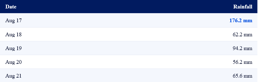
What made this spell notable wasn't just the size of day one it was that the days after never really gave the city a break:
Every single day logged double-digit rainfall. By the time the spell broke, the five-day total stood at 454.4mm the kind of number that would ordinarily represent close to two full months of Islamabad's rain, delivered in less than a week.
Inside the Bursts
Daily and even hourly totals only tell part of the story. The real intensity showed up in short, violent bursts buried inside the broader spell.
At 4:24 AM on August 21, our station clocked an instantaneous rain rate of 225.8mm/hr a brief but extreme downpour, over almost as quickly as it started. Two days earlier, at 4:28 AM on August 19, wind gusts spiked to 27.4 km/h at the exact moment that day's heaviest rain burst hit.
This is the value of minute-by-minute ground data: it doesn't just tell you that it rained. It tells you when the risk actually spiked.

What Else Moved
Rain wasn't the only variable in motion. Through the five-day spell:
- Temperatures dropped the average fell from around 29.2°C in the days before the spell to 26.1°C during it, a roughly 3°C cool-down.
- Humidity stayed saturated averaging above 90% for the entire spell, meaning the air barely had a chance to dry out between downpours.
Zooming Out
Put in the context of the wider monitoring window, the scale of this spell becomes even clearer. From August 1 to September 2, our NUST station logged:
- 853.2mm of total rainfall well over a season's worth of rain inside a single monitoring window.
- 20 days with measurable rainfall out of 33 days on record nearly two rainy days for every three.
- A single five-day spell (Aug 17–21) accounting for over half of that entire period's rainfall.
Why This Matters
Weather advisories and monthly averages are useful, but they flatten exactly the kind of detail that matters most when rain is actually falling. A forecast might say "heavy rainfall expected." Minute-level ground truth says "61.6mm between 4 and 5 AM" a level of precision that turns a general advisory into an actionable decision, whether that's for city drainage teams, transport operators, or anyone planning around the weather in real time.
This spell was tracked live, minute by minute, on our own ground station network the kind of resolution we believe every forecast should be built on.